TORRE PACHECO
El Cabezo Gordo originated in the Triassic, a division of the geological time scale, approximately 250 million years ago. At this time, the Earth underwent a process of transformation in which important geographical features were formed. During the Alpine orogeny, the African and Eurasian tectonic plates collided, pushing the accumulated marine sediments, and thus forming mountain ranges, mountains and elevations such as El Cabezo Gordo. In this period, all the world was united forming the supercontinent "Pangaea", which was divided at the beginning of the Jurassic. In the Triassic also appeared the first mammals that evolved from the mammalian reptiles and in the advanced Triassic appeared the first dinosaurs. These data show us the age of this mountain, the same as the Sierra Nevada in Granada. Located in the middle of the coastal depression, this mountain is 312 metres above sea level and 3 km long. It is the only elevation in the municipality of Torre Pacheco and is part of the Betic Mountain Range. It is not of volcanic origin like other elevations of Mar Menor like its islands and El Carmolí. Its nature is limestone and marble. It dominates the Campo de Cartagena from the north and the Mar Menor is 6 kilometres away. El Cabezo Gordo is a protected landscape in the following categories: • In 1998, with the Natural Resources Management Plan for the Open Spaces and islands of the Mar Menor and Cabezo Gordo, it was declared a Protected Landscape (Paisaje Protegido) due to its great biotic, landscape, cultural and paleontological interest. • It is part of the Natura 2000 Network with the category of SCI (Site of Community Importance), especially because it is the habitat of five species of bats. • It is also catalogued as an SGI (Site of Geological Interest), formed by sedimentary rocks such as: limestone and dolomites and metamorphic rocks such as marble. • It is a Wildlife Protection Area. • It is part of the Integrated Management Plan for the protected areas of the Mar Menor and the Mediterranean coastal strip of the Region of Murcia 2019, declared a Special Areas of Conservation (SAC).

ÁGUILAS, LORCA
The Regional Park of Calnegre and Cabo Cope occupies a portion of the coastal mountain ranges on the eastern part of our coastline. An amalgam of materials and geological structures converge here. Limestones in Cabo Cope and tilites in Calnegre, as well as fossil dunes, beaches and cliffs are some of its most interesting physical elements. Information and Environmental Dissemination Points: 968 228 937 - 968 228 925

SAN PEDRO DEL PINATAR
The Salinas y Arenales in San Pedro del Pinatar Regional Park is a wetland located between the Mar Menor and the Mediterranean Sea, which has 856 hectares of land, distributed between the towns of San Javier and San Pedro del Pinatar. Download Brochure Regional Park Salinas de San Pedro Guide Regional Park of the Salinas de San Pedro Map Guide Regional Park of the Salinas de San Pedro

MAZARRÓN
The Protected Landscape of the Sierra de las Moreras is a coastal mountain range that raises by the banks of the Mediterranean. The limestone is the predominant material in this area, which is located in the central part of the regional coastline, close to other protected sites such as La Muela y Cabo Tiñoso or Calnegre y Cabo Cope. Environmental Outreach Centre and Information point: 968 228 937 – 968 228 925.

CALASPARRA, MORATALLA
Download Brochure Nature Reserve Cañaverosa

ÁGUILAS
The Cuatro Calas Protected Landscape is located next to the provincial border with Almería. It is a small coastal strip of 222 hectares, in which small reliefs dominated by esparto grass combine with wadis and gullies, including the Saladar de Cañada Brusca and, on the coast, with sandy coves and cliffs. This area was declared a Protected Landscape by Law 4/1992 on the Planning and Protection of the Territory of the Region of Murcia. It is also a Site of Community Importance (SCI) and forms part of the Natura 2000 Network. A natural space of great geological interest and of high environmental value in which the absence of frost allows species unique in Europe to live here, such as the Cornical or the Azufaifo or Arto. Amongst its fauna, we can highlight the Black-headed Turtle and the Lagartia colirroja (Red-tailed Lizard). There are also birds typical of wetlands such as the Stork, and steppe and coastal rocky birds such as the Bonelli's Eagle, the Stone-curlew, the Black Wheatear, the Trumpeter Bullfinch and the Little Tern. This landscape invites you to enjoy our nature and its nature trails: 1-GR-92 Mediterranean Path. 2-SL- MU 18 Path of Cuatro Calas Juan Fº Mota Poveda. Information and Environmental Awareness Points: 968 228 937 - 968 228 925

ALHAMA DE MURCIA, LIBRILLA
Do you want to know what the landscape of the moon looks like without leaving the Earth? Come to the Barrancos de Gebas (gorges), in the centre of the Region of Murcia between the municipalities of Alhama de Murcia and Librilla. This protected natural area stuns visitors with its colours, shapes, contrasts, nature and history, impressing all who tread its stark slopes, with the waters of the Algeciras Reservoir in the background. The Barrancos de Gebas stand as a counterpoint to the environmental contrasts of the Peninsula’s southeast. Few places feature forests as dense as that of the Sierra Espuña, not far from the sub-desert landscape of Gebas. Despite appearances, the area is home to communities of fauna and flora fascinating for how they have adapted to survive under very difficult conditions of low rainfall and intense sunshine. Thanks to all these elements, the Barrancos de Gebas was declared a Protected Landscape in 1995. In addition, their great geological and geomorphological value means that they represent one of the finest examples of badlands in the Region of Murcia, leading to their classification as a Site of Geological Interest (LIG). Ricardo Codorniú Visitors and Management Centre Phone: 968 431 430 E-mail: infosierraespuna@carm.es / Web: www.murcianatural.carm.es

MAZARRÓN
In the Pliocene era (5.3 million years) an event that would determine the evolution of the morphology of the Mediterranean coast took place: the formation of the Strait of Gibraltar, which allowed the Mediterranean Sea to stop being a salty lagoon of small dimensions. In just two years, this opening to the Atlantic Ocean allowed the entry of waters that raised sea levels and occupied spaces until then separated from the sea, a phenomenon known as "marine transgression" - affecting the place where the Gredas de Bolnuevo are located. As these spaces were covered by the sea, the marine currents dragged and deposited various materials (loams, silts, sandstones and gravels) that were sedimented and compacted creating a marine platform, which corresponds to the yellowish materials visible today. Description Las Gredas de Bolnuevo is a relief undergoing continuous transformation. Its profile has suffered wear due to the erosive action of wind and water, but this has not been uniform because its materials have different levels of resistance. This relief is composed of an alternation of fine materials, such as sandy loams, also known as yellow clay, and sandstones, as well as thicker ones such as conglomerates. The sandstone sediments present abundant fossils of marine fauna, while in the clay layers, there are millions of microfossils. The action of tectonics and differential erosion has shaped this unique landscape in which the following processes and geographical accidents are identified: Discordance between the different strata. Those layers of marine origin, composed of sandy loams, sandstones and silts from the Cenozoic, are distinguished from the layer of continental materials formed by reddish conglomerates from the Quaternary. Landslide. Tectonics has caused the rocks to slide down the slope. Paleochannel. Vestiges of an old canal whose waters carried reddish sediments from the Sierra de las Moreras. Faults. In the set, several “normal” type fractures or faults are distinguished, when presenting a vertical displacement of the strata. Deflation processes by wind erosion. The action of the wind causes the detachment of the particles from the loam and silt layers, as they are less compacted. Wind erosion abrasion processes. Gusts of wind with sand particles deteriorate the softer areas located from the base at a height of approximately 45 centimeters, causing the marked narrowing of the lower part of the relief. Ledges and escarpments. The selective action of the wind, the different degrees of strata foundation and carbonate precipitation processes, have led to the emergence of layers which are harder than the rest, forming a "cap" on the shapes and resulting in appearance of ridges or ledges. Honeycomb alveolar erosion. The action of the wind and the water drags the weakest parts of the sandstones, favoring relatively regular and contiguous cavities that resemble the structure of a honeycomb. Declared Natural Monument of the Region of Murcia in March 2019.

YECLA
La abrupta Sierra de Salinas es un macizo montańoso de mediana altitud, lindante con tierras alicantinas. Se localiza en el sector nororiental de nuestra geografía regional. De la misma manera que La Pila, El Carche o Espuńa, estas montańas también forman parte de las Cordilleras Béticas, siendo su roca de carácter calcáreo. Puntos de Información y Divulgación Ambiental: 968 228 937 - 968 228 925

ÁGUILAS, CARTAGENA, MAZARRÓN, SAN JAVIER
The island, islets and rocky reefs are distributed along our coastline. Isla del Fraile in Águilas, in spite of its small surface and fragmentation, has unique natural values.


CARTAGENA, LA UNIÓN
The Calblanque Regional Park is located at the eastern end of our coastline, between Cabo de Palos and Portmán. This enclave is characterised by the great diversity of environments that converge here, with Aleppo pine woods, scrubland, wadis, sandbanks, dunes, paleodunes, coves and cliffs, as well as an endorheic basin in which the Salinas del Rasall (a wetland included in the Mar Menor ZEPA) can be found. In summer, many people come to Calblanque to enjoy its beaches, so it is essential to regulate the access of motor vehicles to the Park in order to guarantee the conservation of this unique environment. Information on the "Calblanque 4:40" beach access management system can be consulted on the website Murcia Natural Visitors Centre Las Cobaticas: +34 649 227 582 Email: infocalblanque@carm.es SCHEDULE: 16th SEPTEMBER to 14th JUNE Tuesday to Saturday: 09:00 . to 14:00. and 15:00 to 17:30h. Sundays and public holidays: 09:00 to 15:00h JUNE 15th to SEPTEMBER 15th (Pending to know the definitive timetable during the period of access to Calblanque) Tuesday to Thursday : 09:00 to 15:00h. Friday and Saturday: 09:00 to 15:00h and 16:00 to 19:30h Sundays and holidays: 09:00 to 15:00h CENTRE CLOSED: - Every Monday, except 1 November and 6 December national holidays. - Public holidays: 1, 5 and 6 January, 1 April, 1 May, 24, 25 and 31 December. - For staff training: 24 February, 26 and 27 May and 15 and 16 December. Download Brochure Regional Park Calblanque Download Inherit Región de Murcia

ALHAMA DE MURCIA, FUENTE ÁLAMO, MURCIA
Download Brochure Regional Park El Valle y Carrascoy

CARTAGENA, SAN JAVIER, LOS ALCÁZARES
Download Brochure Islands and Spaces in The Mar Menor Vive el Mar Menor

YECLA
Gran estructura pétrea con paisaje de gran belleza y singularidad. Llaman la atención los fenómenos erosivos que han provocado en las paredes rocosas: huecos, cuevas, abrigos y superficies horadadas con forma de panal o alveolar. Una zona de indudable valor arqueológico, en la que destacan la Cueva del Mediodía y Cantos de Visera, así como las insculturas denominadas cazoletas, al pié del Monte conocido como de los Moros o Arabilejo, en el que se inspiran numerosas leyendas. La vegetación está dominada por el pino carrasco (Pinus halepensis), aunque se encuentran algunas encinas en umbrías y numerosas especies de flora, algunas de ellas endémicas. Cuenta con abundante y variada fauna de invertebrados, reptiles y mamíferos. Aunque sobre todo destaca por contar con la mayor diversidad de aves del altiplano Jumilla – Yecla. Acceso: Se realiza por la Ctra. A-18 Yecla – Montealegre del Castillo, tomando a la izquierda un ancho camino de tierra a la altura del kilómetro 15. Tras 1,8 km. por esta pista se toma a la derecha un camino que pasa por la Casa de Vicente y que nos conducirá hasta el monte. También puede accederse por la MU-404 (Yecla – Fuenteálamo), desviándonos a la altura de la Casa Don Lucio. En él se localizan dos estaciones de arte rupestre: Cantos de Visera y Cueva del Mediodía. Ambas están incluidas en la Declaración de Patrimonio de la Humanidad para el Arte Rupestre del Arco Mediterráneo, por la UNESCO en el año 1998. Estas manifestaciones pictóricas nos situarían en una secuencia cronológica entre el VI y el II milenio a.C., siendo el estilo naturalista levantino (Cantos de Visera I y II) el más representativo dentro del conjunto de estilos identificados y que nos situaría en un momento de actividad Neo-Eneolítico, a caballo entre el IV y III milenio a.C. La Visita a las pinturas rupestres Cantos de Visera del Monte Arabí, siempre requerirá la presencia de un guía acompañante. Los servicios de guías se ofertan a grupos de un mínimo de 15 y un máximo de 25 personas y deberán ser concertados con 48 horas de antelación. 968790901 (atención al público de lunes a viernes de 09.00 a 13.00 horas) o museoarqueologicodeyecla@gmail.com

ALHAMA DE MURCIA, TOTANA
En el fondo del Valle del Guadalentín, entre Sierra Espuña y la Sierra de Carrascoy, se encuentra este Paisaje Protegido, camuflado entre un amplio mosaico agrario de cultivos extensivos de regadío, cultivos de arbolado y construcciones humanas, donde aparece en su mayor expresión la vegetación natural de la zona: el saladar. Es una llanura salina en torno a diferentes cursos fluviales, destacando las ramblas de Las Salinas y La Quebrada de Beatriz, o el conocido cauce del río Guadalentín, que es el más importante y que le da nombre. La superficie protegida se corresponde con cuatro áreas de saladar aisladas entre sí, consideradas relictos de un área de saladar mucho mayor en décadas pasadas. Es Lugar de Importancia Comunitaria (LIC) por estar aquí representados siete hábitats de interés comunitario, siendo el de las estepas salinas de interés prioritario. Además, está designado como Zona de Especial Protección para las Aves (ZEPA) por la presencia de la cigüeñuela (Himantopus himantopus) y ortega (Pterocles orientalis). Más información: www.murcianatural.carm.es/web/guest/saladares-del-guadalentin

CARTAGENA
On the central stretch of the coast, a large stone mass rises above the waters of the Mediterranean. The materials we can find there are mainly limestone in nature, with both metamorphic and volcanic rocks present. Beaches, cliffs and small coves endow this place with great scenic value. Information and Environmental Awareness Points: 968 228 937 - 968 228 925

ABARÁN, BLANCA, FORTUNA, MOLINA DE SEGURA
The Sierra de la Pila Regional Park is located in the north-east of the Region of Murcia in the municipalities of Abarán, Blanca, Fortuna and Molina de Segura, closing the southern part of the Altiplano region. Its enormous environmental, biological, geomorphological and cultural richness, as well as its good state of conservation, more than justifies its protection. In addition to being a Regional Park, it is also protected at European level: Special Protection Area for Birds (SPA) due to the presence of an important colony of red-billed choughs and a Site of Community Importance (SCI) due to the presence of thirteen habitats of community interest, of which four are of priority interest. This steep and rugged mountain range, whose maximum altitude is "La Pila" peak at 1,265 metres, has been little altered by humans, with few population centres in the surrounding area, the most important being the small hamlets of La Garapacha and Fuente Blanca. Contact: sierradelapila@listas.carm.es (mailto:sierradelapila@listas.carm.es) More info: www.murcianatural.carm.es (http://www.murcianatural.carm.es) Sierra de la Pila Regional Park Brochure: (https://murcianatural.carm.es/c/document_library/get_file?uuid=85bffa9e-79a9-4978-9099-25494ef45c0e&groupId=14) Sierra de la Pila Regional Park Map: (http://www.murcianatural.carm.es/c/document_library/get_file?uuid=6d121710-f063- 4324-8dc5-fb7bc47134f6&groupId=14) Geological Guide to the Sierra de la Pila Regional Park: (http://www.murcianatural.carm.es/c/document_library/get_file?uuid=379ddb47-ffaa-41ae-924f-a922bd4a0047&groupId=14) Construction typologies in the Sierra de la Pila Regional Park: (http://www.murcianatural.carm.es/c/document_library/get_file?uuid=b9b29c75-8a2c-4518-94f9-b4dca949911b&groupId=14) PORN Regional Park Sierra de la Pila: (https://www.borm.es/eli/es-mc/d/2004/5/14/43/dof/spa/pdf)


ALEDO, ALHAMA DE MURCIA, LIBRILLA, MULA, PLIEGO, TOTANA
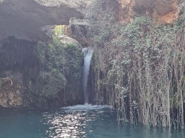
The Regional Park of Sierra Espuña is located in the heart of the Region of Murcia. It is a mountainous massif whose nature is fundamentally calcareous. This massif surpasses 1,500 meters of altitude above sea level. At its summits there are interesting karstic landform. Information and Environmental Points: +34 968 228 937 - +34 968 228 925 Download Brochure Regional Park Sierra Espuña

PLIEGO
The Sima de la Higuera (Cave of the Fig Tree) in the municipality of Pliego, is the largest cave system known in the Region of Murcia's subsoil. More than 5,500 meters long, it features some very special characteristics due to its "hypogenic" (formed in the interior of the earth) nature. Its entrance is located in Monte del Cabezo y Cuesta de Aledo, at an elevation of 485 meters, next to a fig tree, for which it was named. In it some unique speleothems (types of formations in the cavity due to mineral deposits, such as stalactites and stalagmites) have developed, as well as a whole series of "hypogenic" cavities of hydrothermal origin, among the most representative in Europe. The type of karst system present here can only be found in 5-10% of the caves on the entire planet, with morphologies and structural features of worldwide interest, such as its double cone or "Paradise" chamber. A proposal is currently being advanced for the classification of its more than 22 hectares as a Natural Monument.